DIGITAL DOCUMENTATION OF WORLD HERITAGE SITES
The digital documentation and creation of educational assets of 10 world heritage sites
Digital Documentation of World Heritage Sites
The digital documentation and creation of educational assets of 10 world heritage sites
About the Projects:
- Role: Digital Production Manager, CyArk
- Technology: photogrammetry, laser scanning, structured light, 3d modeling, animation, video
- Partners: National Park Service, ICOMOS, UNESCO
While working as the digital production manager at CyArk, I had the opportunity to work on over 20 world heritage documentation and education projects. Our mission with each project is to accurately document world heritage site, to have this information accessible through a free 3D online library, and then create interactive assets with the data for educational use. Below is a sampling of several projects and their interactive media.
- Jamia Khudabad Mosque, Pakistan - 3D model example
- Brandenburg Gate, Germany - 3D model example
- Shoshone Dam, USA - Educational Video example
- History Philadelphia, USA - Point Cloud to 3D Model Animation example
- Lukang Longshan, Taiwan - 3D Model Animation example
- Ancient Corinth, Greece - VR Education Project example
- Bagan, Myanmar - VR Education Project example
- Japanese American Confinement Site: Honouliuli, USA - Community Education Project example
- History New Orleans, USA - Conservation Site Maps for City Restoration example
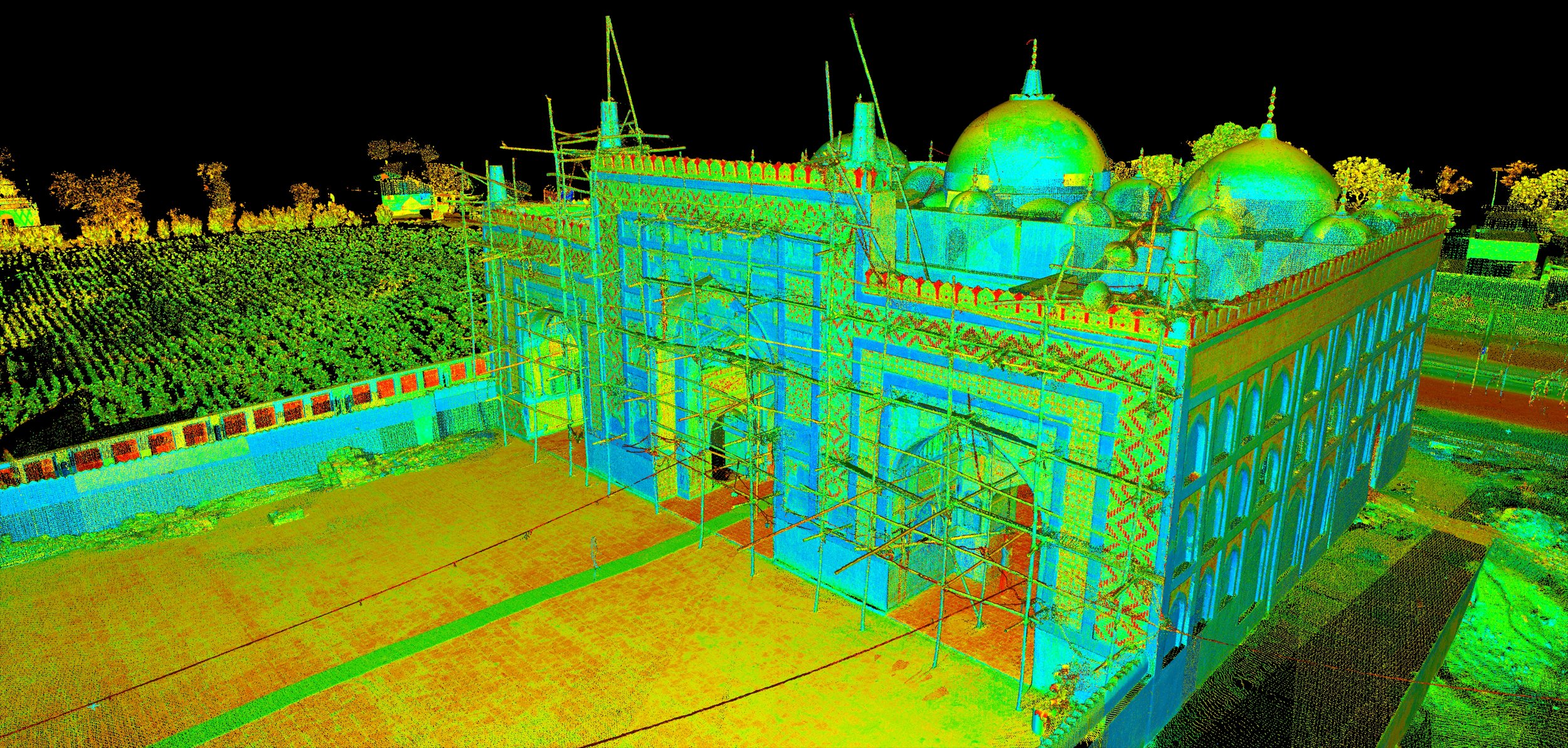
3D Model: Jamia Khudabad Mosque
Built during the rapid decline of the Mughal Empire in the first two decades of the 18th century, the Jamia Khudabad Mosque (the Royal Mosque of Khudabad) was likely intended to showcase the final stance of wealth, power, and prestige of a diminishing empire. The difficulties inherent in maintaining a structure like the Khudabad mosque have unfortunately left this once outstanding building in poor condition. This is why, in 2015, CyArk worked with a team of local students at the Lahore University of Management Sciences (LUMS) to scan and document what remains at the site and begin to build a restoration plan with Pakistani Government heritage employees.
3D Model: Brandenburg Gate
The Brandenburg Gate is one of the most well-known monuments in Germany. Dominating Pariser Platz (Parisian Square) in Berlin, this Neoclassical gateway is a symbol of Germany’s evolving history, from the emergence of the Prussian Empire as a European power to the country’s split in WWII and its later reunification of East and West Germany. Today, the Brandenburg Gate continues to represent German national pride, but also acts as a global symbol of peace. In preparation for the 25th anniversary of reunification, CyArk partnered with the University of Stuttgart’s Institution of Photogrammetry, to digitally scan the Gate and its surroundings
Educational Video: Shoshone Dam
At the turn of the 20th century, William F. "Buffalo Bill" Cody, began planning a massive irrigation project known as the Shoshone Dam in northeastern Wyoming. He hoped the dam would help transform the arid landscape into productive farmlands and provide much needed electrical power to the surrounding budding towns and cities. We worked with the National Parks Service to digitally document and co-create an educational video about this important site in America’s opening of the west to greater prosperity and development.
Animation: Historic Philadelphia
Philadelphia’s Old City neighborhood occupies a half-mile wide stretch of land along the Delaware River, bounded with the homes and meeting places of America’s founding fathers such as the American Philosophical Society, founded by Benjamin Franklin in 1743, and the Carpenter’s Hall, a modest brick structure which hosted the First Continental Congress in 1774. In 2015, Philadelphia was named the first World Heritage City in the United States. Partnering with the National Park Service we created an animation of what it is like to walk down the streets of this historic city today, ending at Independence Hall.
Animation: Lukang Longshan Temple
The Lukang Longshan temple is both the largest Buddhist temple in Lukang, a coastal city in Western Taiwan, and one of the most well-preserved buildings dating from the 17th century Qing Dynasty. In September 1999, the temple was damaged in an earthquake. The site remains vulnerable to future tectonic activity and is threatened by heavy tourism and airborne pollutants from the sounding city. The fly-over animation was created by point cloud data converted into a 3D model for the Bureau of Cultural Heritage to showcase the city’s encroaching development around this at-risk site.
VR in the Classroom Project: Ancient Corinth in Greece, and Bagan in Myanmar
Our goal in bringing World Heritage sites into the classroom via VR was a way for us to rethink how world history curriculum is being taught today and virtually allow students to explore and discover these historic sites for themselves. We believe that by putting these tools in the hands of teachers and students, we can empower students to engage in deep and immersive learning environments. Below is a video of a 7th grade class from the Mid-Pacific Institute in Hawaii exploring the sites of Ancient Corinth in Greece and Bagan Temples in Myanmar.

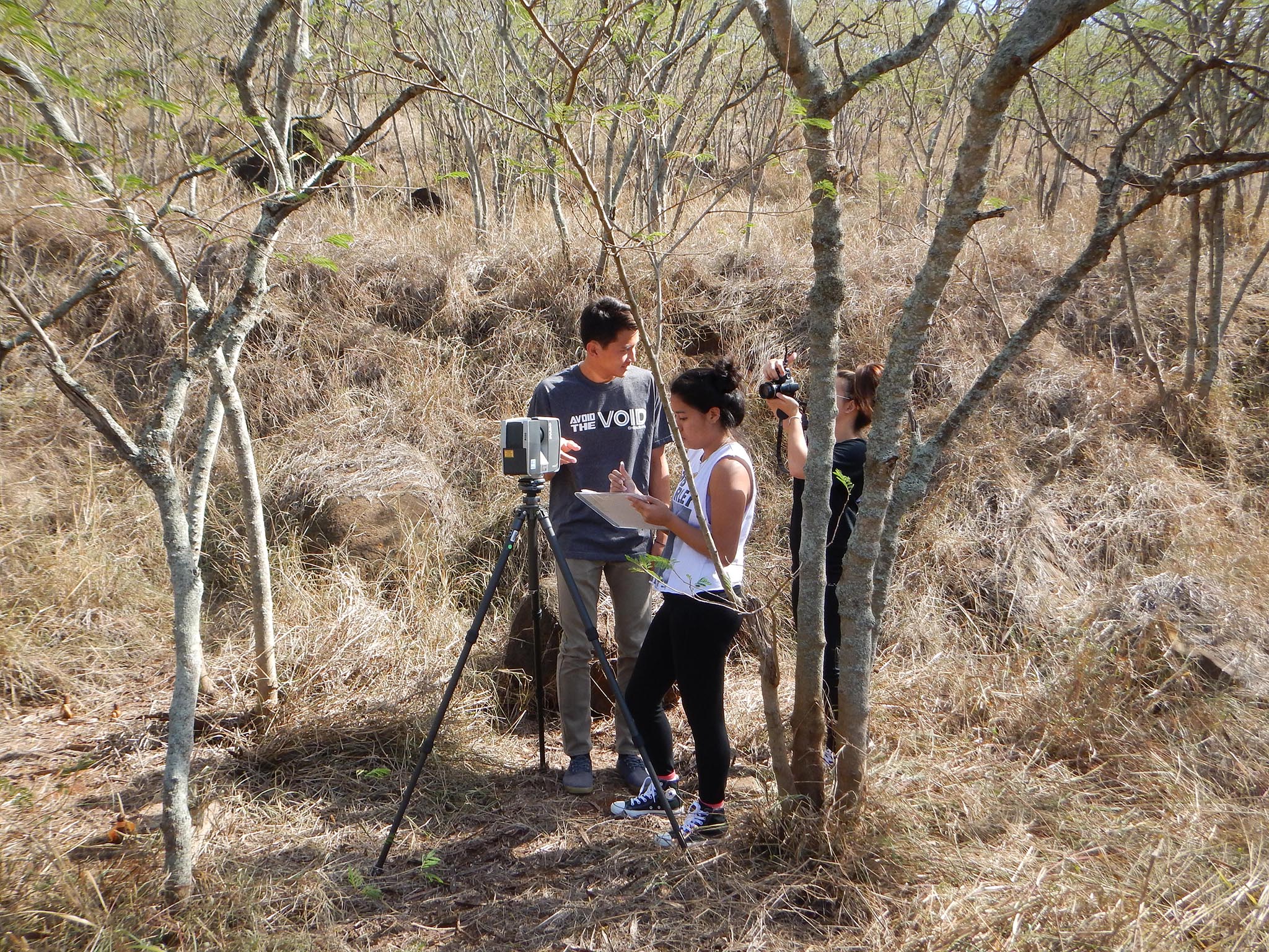
Community Project: Japanese American Confinement Site: Honouliuli
In May 2015, my team at CyArk trained a group of local students who traveled from the Mid-Pacific Institute of Honolulu to the National Park Site of Honouliuli, a Japanese internment camp during WWII. There, the students surveyed and digitally scanned the remains of the site, including building foundations and boundary fences. Upon their return to school, the students were tasked with studying the history of site and produce educational resources for future students and teachers. Because many of the students have family or community ties to the site, in the third phase of this project, the students were asked to go beyond the facts of history and reflect on the significance of what had happened at the Honouliuli Internment Camp through video journals. These moving mementos document not only what the students learned about the history of the site, but also how its repercussions ripple into the present.


Conservation Maps: History New Orleans
Conservation maps were generated by the 3D point cloud data of Historic New Orleans street. Our goal with this project is to provide city conservators with accurate line drawings and models to use for their restoration projects and preservation for many buildings still affected by the 2005 hurricane Katrina.

